
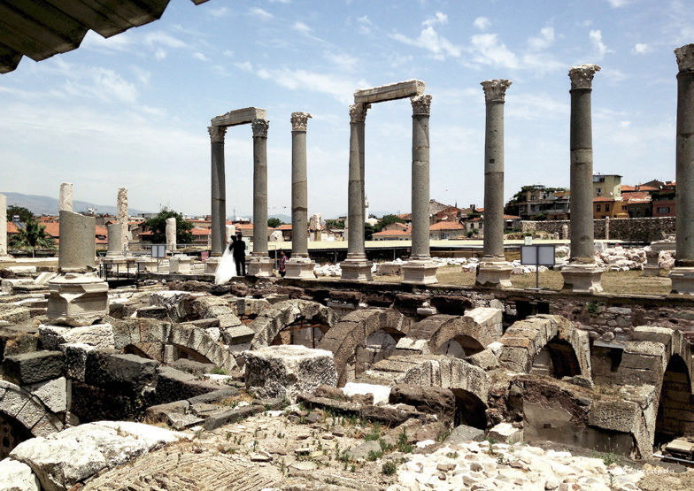
Smyrna / Izmir
Smyrna was one of the most important cities of Anatolia in ancient times. In the first written sources, the name of the city was Smurna (Σμύρνα) in the Aiol dialect and Smurne (Σμύρνη) in the Ionian dialect, at the earliest BC. It appears in the 7th century. The city, which was first established in Bayraklı, was built on the plain between Kadifekale, where today's İzmir city center is located, and the sea. It was moved at the end of the 4th century.
The re-establishment of Smyrna is tied to Alexander the Great. In Pausanias' work, this event is told through a story. Philip's son Alexandros built the present city because of a dream he had in his sleep; While he was hunting on Pagos Hill, on his return from the hunt, it is said that he came to the temple of the Nemesis; Here, in front of the temple, there was a spring and a plane tree overgrown with its water. While he was sleeping under the plane tree, the Nemesis appeared to him and ordered him to establish a city here and to bring the people of Izmir out of the old city. Strabo, one of the writers of the ancient period, states that the establishment of the new city was started by Antigonos, one of the successors of Alexander the Great, and then Lysimakhos continued this task. Excavations reveal the settlement in Bayraklı; It shows that it was ended during the reign of Alexander the Great. Alexander the Great is depicted as the decorator on the city's coins minted in the Roman era.
This newly established city had an important position: It was on the road between Sardis and Ephesos, the two important metropolises of Asia Minor, but had a large and sheltered port opening to the Mediterranean. It was at the focal point of strong and vibrant commercial relations between east and west. Widespread maritime trade caused all major cities in the Greco-Roman world to have a cosmopolitan structure as a common characteristic. The Romans came to Smyrna with 133 BC and AD. They ruled between 395 BC.
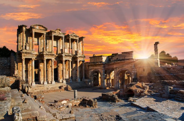
Ephesus / Selcuk
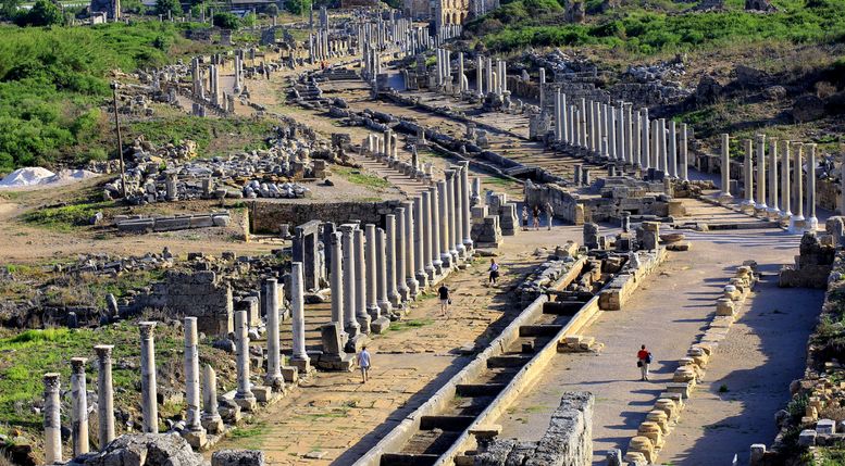
It was an ancient Luwian city located three kilometers southwest of the Selçuk district of İzmir province. The city maintained its importance in the Ionian and later Roman periods with the beginning of Greek colonialism in Anatolia. Its foundation dates back to the Neolithic Age, that is, 6000 BC. It was built in the 10th century BC by Attic and Ionian Greek colonists on the site of the former Arzava capital. It was one of the twelve cities of Ionia during the classical Greek period. The city flourished after falling under the control of the Roman Republic in 129 BC.
Ephesus, which was included in the World Heritage Tentative List by UNESCO in 1994, was registered as a World Heritage Site in 2015. The city is famous for the nearby Temple of Artemis (completed around 550 BC; BC), one of the ancient Seven Wonders of the World. Among many other monumental structures are the Library of Celsus and the II. There is also the ancient theater, which was started in the time of Claudius and completed in the time of Trajan.
The city was the site of several 5th century Christian councils. The city was destroyed by the Goths in 263 and although it was rebuilt, the importance of the city as a commercial center decreased as the port was gradually wiped out by the Küçük Menderes river. The ruins of Ephesus are partially located approximately 30 km south of Adnan Menderes Airport or Kuşadası Port.
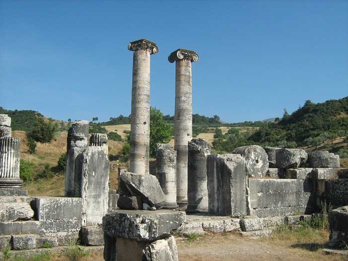
Sardes / Salihli
An ancient city located near Sart town of Salihli district of Manisa and served as the capital of the Lydian state. It was founded in 1300 BC and destroyed in 1200 AD. It is 9 km from the center of Salihli and 82 km from İzmir, and it is spread on both sides of the İzmir-Ankara highway.
The ancient city of Sardis bears the traces of the Iron Age. The Ancient City and its surroundings, which is thought to be surrounded by the largest defense wall outside of Mesopotamia, dates back to BC. It was the capital of the Lydian Kingdom, which ruled between 1,200-546. Sardes is the place where money was first printed according to known history. It is also the beginning of the famous King's Road in history. The word "sard", which is the Western name of the orange quartz stone, which has been used as a precious stone for a long time, comes from the Sart region where the stone was mined in ancient times. Quartz stone and gold are still being extracted here. There are also the first known theater ruins in Sart, and they are being tried to be unearthed. In addition, about 5 km north of Sardis, there is the Lydian royal cemetery, which consists of approximately 85 tombs, called "Thousand Hills".
The Temple of Artemis, one of the 7 temples of Western Anatolia, is located in the town of Sart. Its historical library and royal thrones are still largely intact and open to visitors. The majority of the historical artifacts in here are exactly the same, and the originals are exhibited in the Manisa Ethnography Museum.
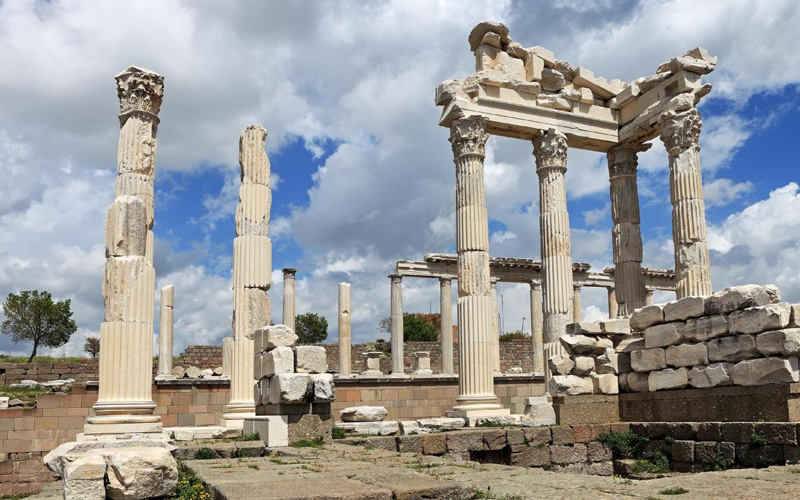
Pergamon / Bergama
It is a district of Izmir, Turkey. The district is surrounded by Aliağa in the south, Kınık and Manisa provinces in the east, Balıkesir province in the north, Dikili in the west and the Aegean Sea in the southwest.
It is the most important district of Bakırçay basin in terms of agricultural activities, industry, trade, history and tourism. Bergama, which has monumental structures belonging to the Ionian, Hellenic, Roman and Byzantine periods, is considered one of the two representatives of cultural tourism in İzmir, together with the district of Selçuk. The ancient city of Pergamon, located in the center of the district, is important as the culture, science and art center of the Hellenistic period. The most important vegetation is stone pine and cotton plant.
Bergama district center is established on the hillside where the ancient city of Pergamon, which was the capital of the Pergamon Kingdom during the Hellenistic period, is located. The oldest known history of Pergamon, which was a place where people dealing with agriculture on a small scale, gathered before the establishment of the Pergamon Kingdom, is considered to be the 3rd millennium BC. The oldest place in the region is Yortanlı Cemetery.
Ancient city, BC. It was the capital of the Pergamon Kingdom, which became one of the most powerful Hellenistic kingdoms in Anatolia between 280-133 and is equipped with many important architectural works. The Pergamon Libraries, one of the most famous buildings of its period, and the Pergamon Asclepieion, the health center of the ancient world, were built.
Roman Empire BC In 133, he took over the city and state of Pergamon by testament. As a Roman provincial metropolis, Pergamon continued to compete with the other metropolises of the Asian province, Smyrna (İzmir), Ephesus (Selçuk). According to Physician Galen, the population of the city center of Pergamon was BC. In the 2nd century, it reached 120,000. The city suffered great damage in the earthquake in 262.
The city, which was exposed to Arab raids in the 7th and 8th centuries, was conquered by the Arab commander Mesleme in 716. The city, whose men were killed and women and children were sold as slaves in this incident, remained desolate for about 200 years.
It was rebuilt in 1170 during the reign of Byzantine emperor Manuel I. The city, which was abandoned by the Byzantines in 1302, remained under the rule of Karesioğulları, who operated in this region a short time later. Ibn Battuta, who came to the city in 1333, stated that this was a devastated town, but that it had an extremely fortified castle.
Klaros / Ahmetbeyli
It is one of the two important oracle centers of the Oracle God Apollon in Anatolia. It is in the Menderes District of İzmir, on the plain of the Ahmetbeyli (Ales) Valley, 13 km from Kolophon (Değirmendere) in the north and 2 km from Notion in the south.
The Achaeans who migrated to this region at the end of the 13th century and the beginning of the 12th century BC settled in the city of Kolophon, which was founded by the Carians. Rhikos, who was the oikiste (leader, founder) of the first immigrant group, later married Manto, an immigrant group from Thebes. It is told that the Klaros Prophecy Center was formed from the tears of the Mantle.
Klaros gained fame during the time of Mopsos, the sons of Manto and Rhaikos. The famous seer of the Trojan War, Kalkhas, came to Klaros and met Mopsos in a competition. Losing this competition, Kalkhas dies from his grief. According to another version, he does not die here. Moving south, he founded the city of Perge. According to Strabo, Selge in the Kalkhas Pisidia Region is among the ktistes (founder) of the canteen. Although the first seer in Klaros was a woman, in later periods the seers were always chosen from men.
Klaros, which was only open to the application of city delegates before, started to accept personal applications after Alexander the Great (V. Alexander) made a personal application to Klaros. Klaros, which became very famous after this event, is an Apollon prophecy center that also accepts the Barbarians (non-Greek peoples). With the spread of Christianity in the 4th century AD, Claros was abandoned.
Teos / Seferihisar
Information about the ancient city of Teos and archaeological research indicate that the first city settlement is very early, due to its geographical location, commercial relations gained importance until the 6th century BC, and its history can be traced back to ancient Egypt. Documentary director Tekin Gün, who conducted research on the ancient city settlement and history in 2013, has different opinions in the light of archaeological and scientific studies on the ancient city. The city's foundation date is a clear information, but we can evaluate it with two views.
The first view is Teos, the oldest settlement on the territory of Seferihisar district, and it can be said that the foundations of the settlement were founded by the Cretans who fled from the Achaeans in 2000 BC, and that it was a city of the Carians, so that the region has been inhabited for 4000 years.
The second opinion is that the archaeological excavations carried out between 1962 and 1967, the ancient settlement history of the city, revealed that the city has been settled since the Protogeometric Period (around 1000 BC). Although the philosopher Thales of Miletus suggested Teos as the center of the twelve Ionian cities, since it was in the center of the Ionia Region, around 600 BC, this proposal was not accepted.
The commercial relations of the city of Teos in the 6th century BC can be traced back to Ancient Egypt. In general, common views among historians were established in the history of the ancient city between 1050-1000 BC. Its founder is known as Athamas, the son of Dionysus. Teos is one of the 12 Ionian cities, and the Temple of Dionysus right next to the road was built by Hermogenes of Priene at the beginning of the 2nd century BC. It is the largest of the temples built in the name of Dionysus in Anatolia. It was repaired frequently during the Roman Empire, but it was still badly damaged by earthquakes.
Didima – Apollon / Didim
The first settlement traces of Didim district date back to the Neolithic Period (8000 BC). In the 16th century BC, the existence of Mycenaean, Cretan and later Aka colonies is seen. After the Persians, Romans and Byzantines, after the Battle of Manzikert in 1071, after the gates of Anatolia were opened to the Turks, this region, which was first called Karia, passed into the hands of the Turks. After the 1st Crusade, it passed into the hands of Byzantium again. With the establishment of the Menteşe Principality in Caria after 1261, Didim and its surroundings were included in this principality.
During the Ottoman Empire, it continued its existence under the name "Yeronda - Yoran". In accordance with the Treaty of Lausanne on March 23, 1924, the refugees from Thessaloniki's Pravuşta region and its villages (Kuçkar, Devekıran) became the first owners of Didim. The Greeks who went from Yoran, on the other hand, established a village in Nea Yeronda, which means New Yoran.
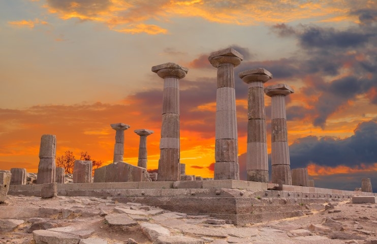
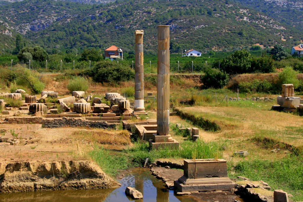
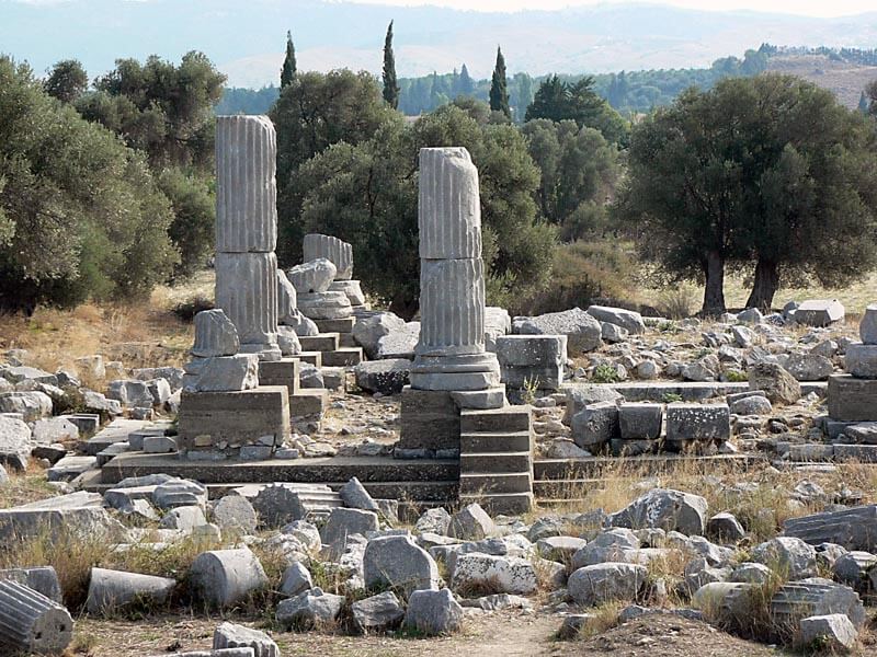
Assos - Behramkale / Canakkale
It is an ancient city located in Behramkale Village, approximately 17 km south of Ayvacık district of Çanakkale. It was established on the summit and slopes of a volcanic hill at the southern end of the region called Troas in ancient times, opposite the island of Lesbos. The region, which has been under the rule of Lydia, Persia, Pergamon, Roman throughout history, was abandoned in the Middle Ages.
It is not known who the first settlers in the city of Assos were, but it is understood from the archaeological data that the city has been inhabited continuously since the Bronze Age. The region developed and prospered by being inhabited by the Aeolian colonies coming from Lesbos Island (Lesbos) in the 7th century BC. In the 6th century BC, the Kingdom of Lydia wanted to gain political power over the Hellenic cities on the coast, and as a result, Assos came under the rule of the Lydian Kingdom in 560 BC. Persian domination began as a result of the Persians ending the Lydian rule in 546 BC. There was no change in the tax system during this period. The tax collectors were Hellenic rulers rather than Persians. During the establishment of the Athenian city union, which was established under the leadership of the Athenian State against Persian domination in the 5th century BC, Assos remained among the founding members in return for a payment of 1 talent per year.
The Persians had begun to leave the Asian shores of the Aegean after their defeats. However, in time, the Persians returned to the Anatolian shores again; Immediately after the signing of the King's Peace (387 BC), which forced the inhabitants of the western Anatolian coasts back into Persian domination, a merchant named Eubolos declared himself the king of the cities of Assos and Atarneus. After his death, Hermesisas, one of his servants, took over the government. Having studied at Plato's school in his youth, Hermesias invited his philosopher friends, especially Aristotle, to Assos. Aristotle married Hermesias' nephew Phtias and lived in Assos for three years. He founded a school of philosophy in Assos in 347 BC and studied life sciences. King Hermesias lost his independence in 345 BC; He was captured by the Persian commander, Memnon of Rhodes, and crucified in Persepolis, and Persian domination began again in the city. Aristotle, who left Assos in 344 BC; Macedonian King II. He went to Pella to raise Philip's son Alexander. Persian domination in the region ended with the victory of Alexander the Great in the Battle of Granikos in 334 BC. Assos was occupied by the Galatians after the death of Alexander the Great. In 241 BC, it came under the rule of the Pergamon Kingdom. King III in 133 BC. With the will of Attolos, the Kingdom of Pergamon passed to Rome, and the city of Assos came under Roman rule. The city flourished during the Roman rule. During this period, it became famous for the productivity of its agricultural lands. Assos, who deified Roman emperor Augustus and his wife Livia, as well as the cults of Athena Polias, Zeus Soter and Asklepios in the early imperial period, accepted Christianity with the influence of the visit of St. Paul and St. Luke to the city after the birth of Christianity. In 381 - 390 AD, in line with the influence of Christianity and the orders of the empire, many temples were closed and destroyed, their stones were used in the construction of churches and residences; In addition, all marble material was burned in the lime pit near the agora to provide the necessary lime for mortar production. The Assos Athena Temple and the altar of the temple were also destroyed at this time. After the middle of the 3rd century AD, the city lost its importance. The settlement in the city, which became the center of the bishopric in the 5th century AD, ended after the 7th century.
Latins, Franks, Seljuks and Ottoman Turks attacked the acropolis many times. Assos, which became a bishopric center during the Byzantine Period, came under the rule of the Seljuk Dynasty in 1080, but after 17 years of domination, the Monk Pierre, one of the commanders of the Crusader army, drove the Turks away from the region, and the Byzantine domination continued here until 1330.
Assos, which was in the territory of the Karesi Principality in the 14th century, was sold to Sultan Murat I in 1359, together with the entire Çanakkale region, and became a part of the Ottoman lands.
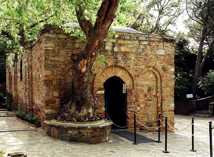
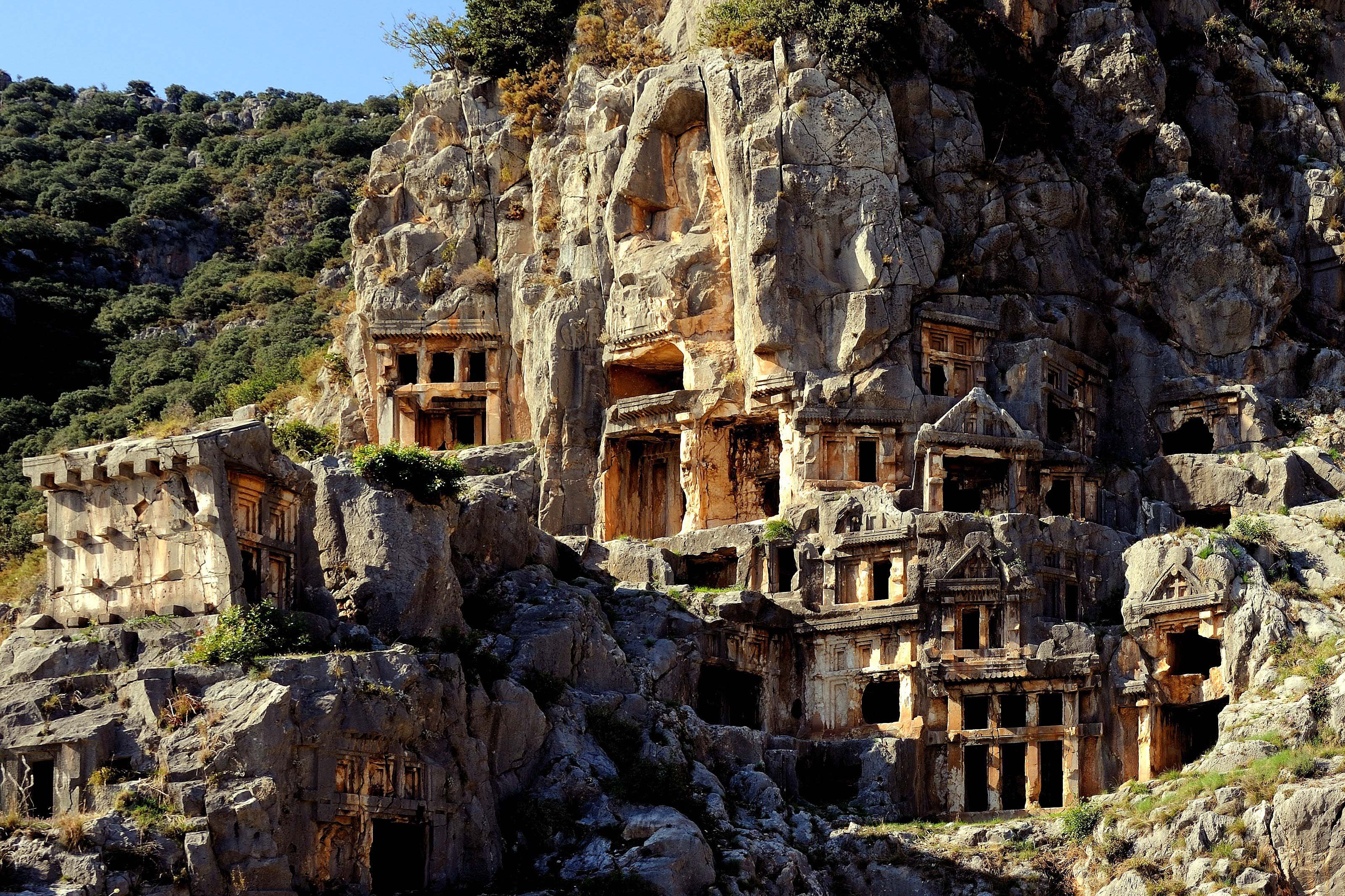
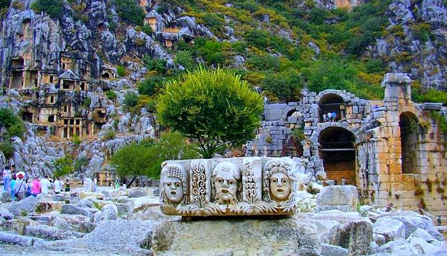
Meryem Ana / Selcuk
Jewish woman who was the mother of Jesus of Nazareth. She is one of the important and holy persons in the New Testament and the Qur'an. She is also known as the Virgin Mary and the Virgin Mary. While Mary was pregnant with Jesus, she married Joseph. Jesus was known as the son of Joseph in the Jewish community to which he belonged. It is emphasized that many of the attributes of Mary, which are believed to be eternal virginity despite having children, are the beliefs transferred to Christianity from the mythological goddess models like Artemis or Isis who married and had children but did not lose their virginity.
The New Testament says little about Mary's family and early life. The 2nd-century Gospel of Jacob (apocrypha) author describes his parents as Jehoiakim and Anne (Hanne).
Mary was dedicated to the Temple of Solomon by her mother on the assumption that she would be a man before she was born. It is believed that Mary lived in present-day Israel and gave birth to Jesus without a father in Bethlehem.
According to the belief of some Christians, Ephesus and the House of Virgin Mary, which are the places where Mary spent her last years, are within the borders of Selçuk district today.
Apart from the fact that the subject of Mary is mentioned many times in the Qur'an, Mary is the only woman whose name is directly mentioned in the Qur'an. The name of the 19th sura is called Surah Maryam and Imran, who is referred to as the father of Mary, is the source of the name of another surah (Al-i Imran).
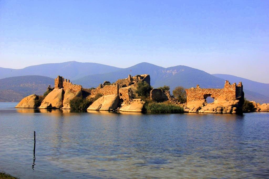
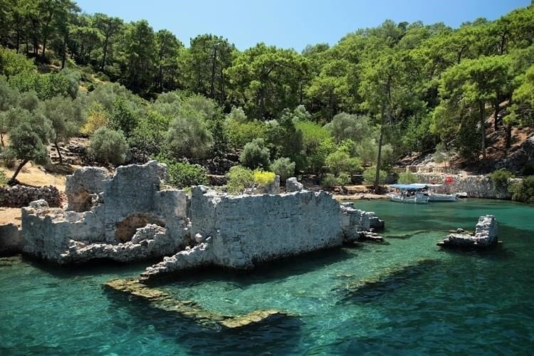
Heraklia / Milas
The Ancient City of Herakleia or Latmos Herakleia is one of the city settlements of the Ancient Ionian region, established within the borders of Kapıkırı Village, 39 km from Milas district of Muğla province.
The site is originally a Carian settlement dating from the 5th century, it became a member of the Delos League by paying annual tribute. The ancient city was turned into a strong border fortification after Halicarnassus came under the rule of Halicarnassus in the 4th century and King Mausolos settled his soldiers in the city. Its location at that time was in the southeast corner of the Latmus sea (like Priene and Miletus) and was connected to the Aegean Sea. In the 4th century, sediments on the banks of the Menderes river closed this connection and formed Bafa Lake at the foot of the 1367-meter-high Latmos granite massif. It is one of the points where the Endymion legend passes. When Strabon defined the city at the eastern end of the Bafa lake, there is a small settlement called Herakleia at the ship anchorage in the Latmos bay, a little ahead, after crossing a small river, there is the tomb of Endymion in a cave. There is the Temple of Athena Latmia, which can be seen from afar because of its remains, and a well-preserved sanctuary associated with the Endymion myth among the rocks.
Carian type tombs where the residences are; rock tombs; There are stone burial chambers. One of the burial chambers is in the middle of the city; others are near the south entrance. The infrastructure is made of cut stone; the superstructure is of marble. It is thought that they resemble the Doric temple with an in antis plan from the outside. Dated to the Hellenistic Period
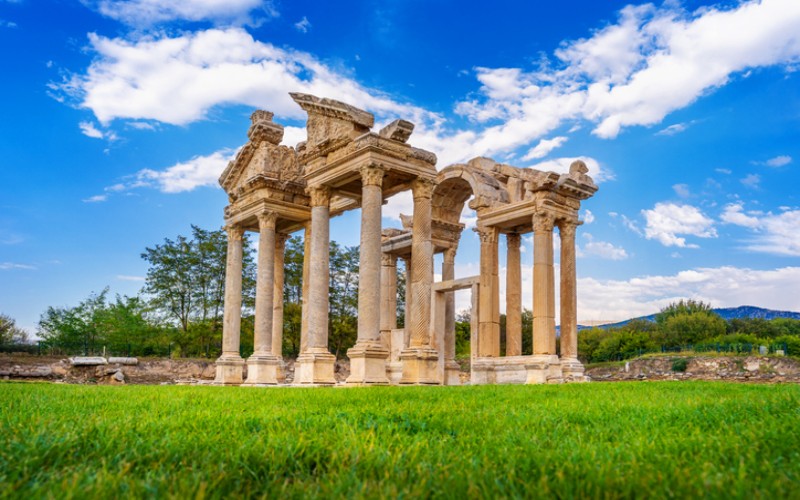
Afrodisias / Aydin
The city, which was founded in the 5th century BC, developed during the Roman Empire, became an important art center, especially sculpture, between the 1st century BC and the 5th century AD, and became famous for the temple of Aphrodite and the ceremonies held in the name of Aphrodite.
The temple built for the city's goddess Aphrodite is the oldest marble building in the city. The boundaries of the sanctuary (temenos) belonging to the temple were clear because of the right of asylum granted to this area. Inscriptions around the temple reveal that this privilege was first given by Julius Caesar and his successor, and later by the Roman Emperor Augustus.
Gaius Julius Zoilos, who is considered the founder of the temple, was honored with the title of Aphrodite priest during his lifetime.
Due to its location in the earthquake zone, the city of Aphrodisias has been severely affected by many earthquakes throughout its history. It is known that there were major earthquakes here, especially in the 4th and 7th centuries. The 4th century earthquake also changed the water flow channels in the area where Aphrodisias is located, making some parts of the city susceptible to flooding. Evidence of the evacuation system, which seems to have been built with urgency to solve the flooding problem, can still be seen today. After the earthquake in the 7th century, Aphrodisias never fully recovered and fell into disrepair. Over time, the ruins were partially covered by the Geyre village area.
At the beginning of the 20th century, a part of Geyre village was emptied again due to an earthquake, and the remains under the evacuated area were revealed. In the 1960s, Geyre moved to its present location and became a town, considering the possibility of an earthquake.
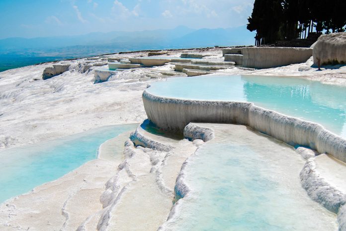
Pamukkale / Denizli
Two thousand years ago, the Kingdom of Pergamon could not resist this attraction and built the city of Hierapolis next to the travertines. During this period, Hierapolis served as a thermal health center and its sources believed to be healing were visited by people from different parts of Anatolia seeking health and beauty for thousands of years. Today, thermal pools continue to be visited in search of beauty and health.
You can enter the waters where the people of the ancient world used to swim thousands of years ago and watch the magnificent view of the travertines. However, this natural beauty, which took thousands of years to form, is quite sensitive. Therefore, only certain parts of it can be walked around and its waters can be entered. Those who want to stay longer in Pamukkale and benefit from its healing waters can both stay in the thermal facilities located near the ancient city and travertines and enjoy massage, thermal waters and mud baths.
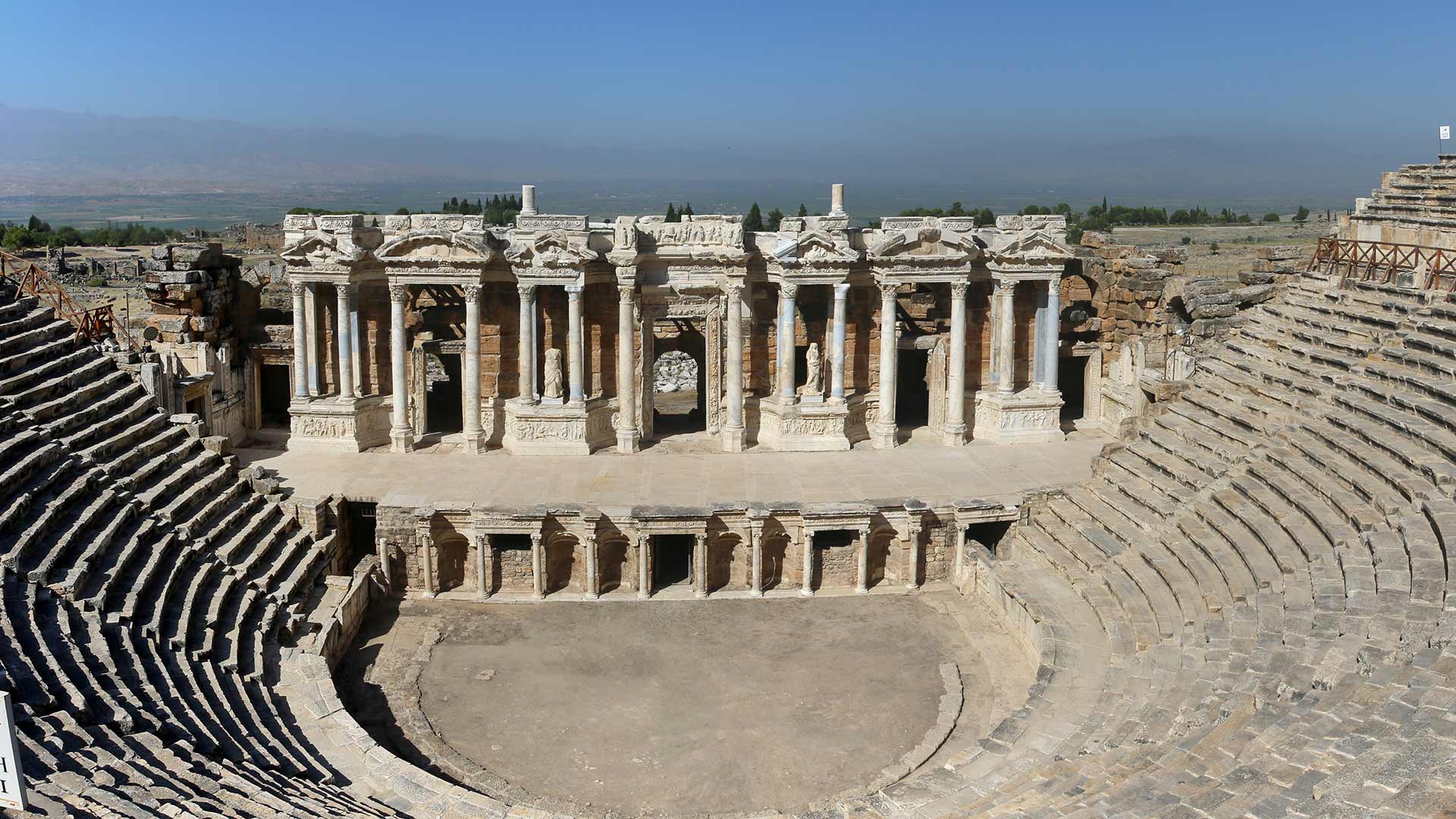
Hierapolis / Denizli
The ancient city of Hierapolis, located 17 kilometers north of Denizli, is called "Holy City" in the archaeological literature, due to the presence of many temples and other religious structures known in the city. It is discussed in which old geographical region the city is located. With its geographical location, Hierapolis is among the various historical regions surrounding it. The ancient geographers Strabo and Ptolemaios claimed that Hierapolis was a Phrygian city with its proximity to the cities of Laodikeia and Tripolis, which border the Caria region.
There is no information about the name of the city before the Hellenistic Period in ancient sources. It is known because of the cult of the Mother Goddess that there was a life in the city before it was called Hierapolis. Although the information about the establishment of the city is limited; King of Pergamum II. By Eumenes II. YY. It is known that it was founded in the beginning of the year and took the name Hierapolis because of Hiera, the queen of the Amazons, the wife of Telephos, the legendary founder of Pergamum.
Hierapolis maintained its original texture by adhering to Hellenistic urbanization principles until the great earthquake in the reign of Roman Emperor Nero (60 AD). The city, which is located on the earthquake belt, suffered great damage from the Nero period earthquake and was completely renovated. After these earthquakes, the city lost all its Hellenistic character and took the appearance of a typical Roman city. Hierapolis became a very important center in the Byzantine period after the Roman period. This importance, MS IV. Being the center of Christianity (metropolis) since the century AD, in 80 years, Hz. It is due to the death of Saint Philip, one of the apostles of Jesus, here. Hierapolis, XII. Towards the end of the century, it passed into the hands of the Turks.
Knidos / Datca
In the light of the archaeological data of the first builders of the ancient city of Knidos, the archeological data points to the Hellenistic and Roman settlement of the ancient ruins. Documentary director Tekin Gün, who conducted research on the ancient cities of Caria in 2014. It is believed that it was built in the 16th century and the settlements around it were inhabited uninterruptedly. Outside the city walls, approximately 7 km to the east. There is a Necropolis (mass grave) spread over a wide area in length.
Knidos;
It was also a very advanced city in science, architecture and art. Eudoxus, the great astronomer and mathematician of the history, the doctor Euryphon, the famous painter Polygnotos and the architect of the Lighthouse of Alexandria, which is considered one of the seven wonders of the world, lived here. Doctor Euryphon and his students founded the second largest medical school of its time in Knidos. The sundial, developed by Eudoxus and the great invention of the period, can still be seen at the site today. The ancient Greek historian, geographer and philosopher writer Strabo of Amasya likens the city to a theater rising from the coast to the Acropolis. He mentions that buildings and private buildings were built on the peninsula that divides the inner and outer harbors into two, and buildings serving the community were built on the embankments formed on the slopes rising with a slight incline to the Acropolis in the city center over the inner harbor. It is seen that 4 main streets with a width of 10 meters extending in the east-west direction are located flat on the embankments, and the connection between the streets is provided by stairs and sloping steep streets.
The peninsula known as Deveboynu used to be an island. An artificial port was created on both sides by connecting the head part to the land. A channel was opened to be used in the transition to the filling area. The northern port was used for military purposes, there were round control towers on both sides and its mouth was closed with chains. The southern one of the control towers still stands today. The inner port in the south was the port where larger and commercial ships docked.
The ancient settlement of Knidos has two theaters, one with a capacity of 20,000 and the other with a capacity of 5,000. The small one to the south, near the commercial port. The big theater in the acropolis, on the other hand, could not reach today because its stones and marbles were taken (transported) by ships in the 19th century.
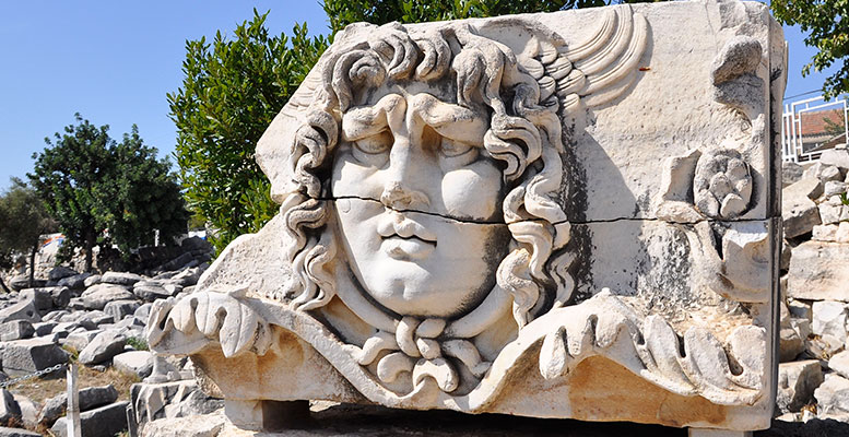
The most beautiful point of the ruins is the Temple of Aphrodite, which overlooks both harbours. The diameter of the temple with a round plan was 17 meters. The statue of Aphrodite was in the middle of the temple. Doors opened to the statue. Now only the pedestal of the statue is visible.
One of the interesting points of the ruins tour is the sundial that shows the seasons and time. At the top is the Temple of Apollo and the city rises towards it like a theater. The Corinthian Temple just above the Theater below was the work of the architect Stratos.
A church was built on the Doric temple, located on the terrace in the middle of the road leading to the Apollon temple, in the early Christian period.
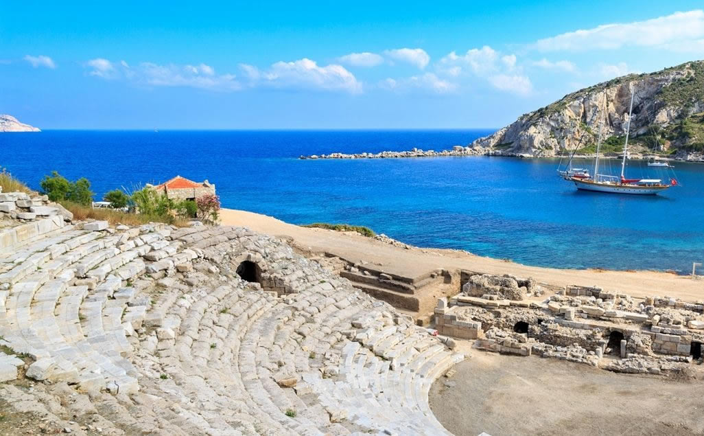
Kleopatra / Gocek
Cleopatra Bath Bay, located in Muğla Göcek, is one of the most preferred bays for yacht tours. There are historical ruins from the Lycian period in the region. Remains of historical baths can be found under the waters of the bay. The bay took its name from this bath, which is said to have been built by Cleaopatra.
The unique green nature, which is frequently seen in Göcek's bays, can also be found in Cleopatra Bath Bay. It is possible to take long walks among the green trees around. The bay, which is one of the important areas for sea tourism, welcomes thousands of local and foreign tourists every year. Access to Cleopatra Bath Bay is provided by sea, with tours departing from Göcek or Fethiye.
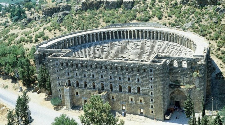
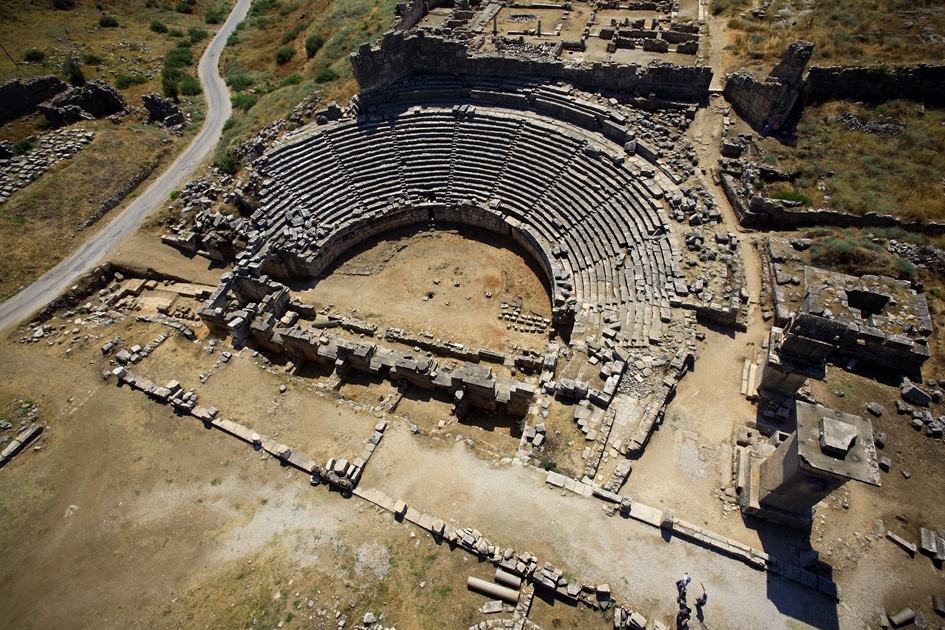
Aspendos / Antalya
Located in Sarıabalı Village of Serik district of Antalya, Aspendos Antique Theater is 45 kilometers from the city center. Transportation to Aspendos Antique Theater is done by private car, by following the Mersin - Antalya road to Serik, by taxi or by Serik minibus.
Aspendos Antique Theater, which is one of the Roman theaters that has survived with the least damage, was built during the Antique Age. The ancient theater, which is a very large structure with an audience capacity of 12.000, was repaired during the Seljuk period. There are basilica, agora, aqueduct and many ruins that you can see around the Aspendos Antique Theater.
Xanthos / Kas
Xanthos Ancient City, which was built within the borders of Kınık District of Antalya's Kaş district, is 210 kilometers away from the city center. Transportation to the ancient city is made by following the Antalya - Denizli road to the Kaş sign, by taxi or Kaş minibuses.
According to the researches, The ancient city of Xanthos, which is thought to belong to the 8th century, is on the UNESCO World Heritage List. As a result of the invasions of the Persians to the region, the people of the region left the city and most of them committed suicide. The ancient city of Xanthos, which was revived with the return of the survivors to the region, was used as the capital of the Lycian League in the following process and was later captured by the Roman Empire. Among the structures you can see in the Xanthos Ancient City are the ancient theatre, bath, temple and houses of various sizes.
Patara / Antalya
Patara Ancient City, one of the oldest cities of Antalya, is located in Kalkan Town of Kaş district. You can go to the ancient city of Patara, which is 220 kilometers away from Antalya, which is one of the historical buildings that you must see in Antalya, by following the signs of Yazır, Korkuteli, Söğüt, Bekçiler and Kumluova, respectively, from the city center with your private vehicle. You can also reach the region by taxi or Kalkan minibuses.
The ancient city of Patara, which was the capital city of the Lycian League, dates back to BC. It was built in the 8th century. Among the works that can be seen in the ancient city, which is home to many buildings, are the ancient theatre, bath, temple and stadium. Since the ancient city of Patara was the capital of Lycia, there is also a parliament building in the city, where decisions about the city's administration are taken. In this respect, the ancient city, which is a first in the world, is also the sanctuary of Santa Claus, St. It also attracts attention with its feature of being a city where Nicholas lived.
Olympos / Antalya
On the southern coast of Antalya, the second important port city after Phaselis is Olympos. The city takes its name from Tahtalı Mountain, which is one of the western extensions of the Taurus Mountains, 16 kilometers to the north, with a height of 2 thousand 375 meters. It is within the borders of Beydağları-Olympos National Park. Although the exact date of its foundation is unknown, Olympos, which is mentioned in the Lycian Union coins minted in 167-168 BC, is one of the six cities with three voting rights in the Lycian Union.
On the south shore, the polygonal masonry wall of the Hellenistic Period and the part indicating the Roman and Byzantine repairs next to it can be seen. There are building remains from the late periods in the small and steep acropolis near the river mouth. The small theater with a Hellenistic foundation and Roman repairs on the south bank of the river is in ruins and one side of the entrance is well preserved.
Another important visible structure of the city is the temple gate located 150 meters west of the river mouth. It is understood from the statue base in front of the door that it was built in the name of the Roman Emperor Markus Aurelius (AD 172-173) from the architectural fragments that it belongs to a small temple in the Ionic order. The most interesting among the ruins is the Sarcophagus of Captain Eudomus, which was unearthed during the excavations carried out by the Antalya Museum. The sarcophagus, located in the hollow of the rock right next to the river mouth, is of great importance both in terms of giving the captain's name in the emotional poetic dedication inscription and giving the shape of his ship in the relief of the ship on its long side.
To the east of Olympos, 300 meters from the beach, there is the famous Çıralı settlement with its magnificent beach where the Carettas lay their eggs and the beach dunes where many plants live. A fire constantly erupts from the southern slope of the hill called Çakaltepe, a few kilometers southwest of the city. This natural phenomenon, which is very impressive especially at night, is nothing but the fact that methane gas has reached the earth from the same point for centuries. This natural event is identified with the Chimera Monster, which lives in Lycia and is believed to spew fire from its breath, and in this way, Olympos hosted the Legend of Bellerophontes. It is possible to see the foundations of some structures around the flames and the sacred road, whose original blocks can be seen from time to time, in the area used as the cult center of the blacksmith God Hephaestus and as a religious center in the Roman and Byzantine periods. The Byzantine Church, the inner walls of which are decorated with frescoes, is the most monumental ruin in the area.
Perge / Antalya
It is located in Barbaros Neighborhood of Aksu district of Antalya. You can reach the ancient city of Perge, which is located 16 kilometers from the city center, by following Aspendos Boulevard from the city center in the direction of Aksu, by taxi or by taking the Aksu minibuses from the bus station.
B.C. The ancient city of Perge, built in 1200, was used by the Hittites for a long time. The ancient city, which hosted first the Roman and then the Byzantine Empire in the historical process, has survived to the present day.
Among the buildings you can visit in the Ancient City of Perge are the ancient theatre, Turkish bath, stadium, house and columned street. Many of the structures have been damaged due to natural disasters over the centuries. The prominent structure of the Perge Ancient City is the ancient theater. The theater, which is one of the best structures of the period when it was built with a total audience capacity of 15 thousand people, is one of the must-see structures in the region.
Termessos / Antalya
Termessos is one of the best preserved ancient cities in Turkey. It is located on the Korkuteli road, 30 kilometers northwest of Antalya. It was built on a natural platform in the southwest of Güllük Mountain, at an average altitude of 1,150 meters above sea level. It is hidden among many wild plants and bordered by dense pine forests. Termessos, with its peaceful and untouched appearance, has a different and impressive atmosphere than other ancient cities. Due to its natural and historical riches, the city has been included in the national park that bears its name.
The double "s" in the name Termessos provides linguistic evidence that the city was founded by Anatolian people. According to Strabo, the inhabitants of Termessos, the Pisidian people, called themselves Solymi. This name, which was also given to the mountain where they lived, comes from Solymos, one of the Anatolian gods, who was identified with Zeus in the following years and caused the rise of the cult of Zeus Solymeus here. Termessos coins usually have this god and the coins are named after him.
IZMIR MIETWAGEN
OUR SERVICE POINTS
Gaziemir-Izmir havalimanı yanı
İzmir / Türkiye